Navigating high-altitude mountain environments requires continuous awareness of two critical environmental factors: elevation gains and barometric pressure fluctuations. When trekking through remote alpine wilderness, deep river canyons, or dense forest canopies, cellular service completely vanishes. Standard smartwatches that rely heavily on cloud computing, cellular data, or active phone links become ineffective when offline, often draining battery power rapidly within 24 to 48 hours.
To track altitude and air pressure safely in offline environments, trekkers must rely on standalone hardware sensors built directly into specialized outdoor wristwear or handheld field equipment. This comprehensive guide covers how offline barometric sensors function, step-by-step methods to track elevation and predict weather shifts in the backcountry, a detailed buyer’s guide for field gear, and practical FAQs.
The Danger of Relying on Cellular Smartwatches Off-Grid
Many modern fitness trackers and smartwatches rely on Assisted GPS (A-GPS) and cell tower triangulation to establish location and pull elevation data from online topographical maps. When phone service drops, these devices suffer severe operational limitations.
-
Rapid Battery Drain: Without cellular coverage, standard smartwatches constantly boost their antenna transmission power to search for nonexistent cell signals, quickly depleting their batteries.
-
Lack of Real-Time Sensor Data: Smartwatches designed for urban fitness often lack direct physical pressure sensors, rendering them unable to measure atmospheric changes locally.
-
Touchscreen and Glass Vulnerability: Standard glass displays easily crack when exposed to granite outcroppings, heavy rain, or sub-zero mountain temperatures.
To maintain real-time situational awareness off-grid, hikers need self-contained ABC (Altimeter, Barometer, Compass) hardware that operates 100% independently of smartphone connectivity or satellite internet.
Understanding ABC Technology: How Standalone Sensors Work
Understanding the mechanics behind onboard ABC sensors allows you to optimize their accuracy during long treks.
The Barometric Sensor Mechanism
At the core of an offline mountain watch or handheld altimeter is a tiny micro-electro-mechanical system (MEMS) piezoresistive pressure sensor. This sealed internal diaphragm flexes subtly as atmospheric pressure increases or decreases.
Because atmospheric pressure drops predictably as altitude increases, the onboard microprocessor converts air pressure readings into precise elevation figures using standard atmospheric pressure models.
Altimeter vs. Barometer: Resolving the Sensor Dilemma
Because both altitude changes and incoming weather fronts alter ambient barometric pressure, standalone sensors must distinguish between elevation changes and atmospheric shifts.
-
Barometric Pressure Trend: Indicates incoming weather patterns. A sudden drops in air pressure indicates an approaching storm or low-pressure trough, even if your physical elevation remains constant.
-
Altimeter Readings: Measures vertical progress. As you climb higher, air density drops, which the sensor translates into gain in meters or feet.
To maintain precise accuracy on multi-day treks, manual recalibration at known topographical waypoints (such as trail markers, peaks, or campsites) is essential.
Step-by-Step Guide: Tracking Altitude & Weather Off-Grid
Step 1: Calibrate Your Altimeter at the Trailhead
Before embarking on your climb, calibrate your sensor to establish a precise baseline:
-
Locate a known elevation marker on a topographical map or trailhead sign.
-
Access your watch or device’s manual calibration menu.
-
Input the exact current elevation or standard sea-level barometric pressure.
Step 2: Monitor Barometric Pressure Trends for Weather Forecasting
Keep a steady eye on atmospheric pressure changes when setting up camp or taking trail breaks:
| Pressure Trend | Pressure Drift Rate | Likely Weather Outcome | Recommended Action |
| Steady Rise | +1.5 to +3 hPa in 3 hours | Clear skies, stable cold air | Proceed on scheduled ascent |
| Gradual Drop | -1.0 to -2.0 hPa in 3 hours | Approaching cloud cover, light rain | Prepare rain gear, assess shelter options |
| Sharp Drop | > -4.0 hPa in 3 hours | Severe mountain storm, heavy wind/snow | Descend to safer elevation, secure camp |
| Rapid Rise | +4.0 hPa in 3 hours | High wind, clearing conditions | Exercise caution on exposed ridges |
Step 3: Track Ascent and Descent Rates
Maintain a sustainable vertical climb rate (typically 300 to 400 vertical meters per hour for loaded backpackers) to manage physical exertion and prevent Acute Mountain Sickness (AMS). Tracking elevation gains directly on your wrist lets you pace your climb without taking out physical maps during harsh weather.
Ultimate Buyer’s Guide for Offline Trekking Watches
Selecting the right backcountry timepiece requires evaluating durability, sensor precision, battery life, and overall field usability.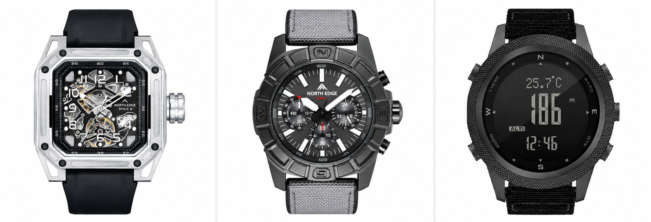
Essential Features Checklist
-
Standalone ABC Sensors: Ensure the device features physical MEMS sensors for real-time altimeter, barometer, and digital compass readings without requiring phone pairing.
-
Extended Battery Longevity: Look for traditional button-cell battery systems (CR2032/CR2025) or high-efficiency solar cells that provide months or years of operational life instead of daily charging cycles.
-
Rugged Casing & Water Resistance: Opt for stainless steel, carbon-reinforced composite, or titanium cases paired with hardened mineral glass or sapphire crystals. A minimum rating of 5 ATM (50m) or 10 ATM (100m) is recommended.
-
Physical Button Navigation: Touchscreens frequently fail in rain, snow, or when operating with thick winter gloves. Textured physical pushers are essential for cold-weather usability.
Top Outdoor Watch Solutions for Standalone Altitude Tracking
When choosing an offline altimeter watch, balancing rugged construction with long battery life is key. Below are three proven market solutions suited for different budgets and operational needs.
Option 1: Premium Multisport GPS Watches (e.g., Garmin Fenix Series)
-
Pros: Advanced topo mapping, full GPS logging, comprehensive health tracking metrics.
-
Cons: Expensive ($700–$1,100+), requires frequent recharging on extended wilderness trips without solar setups.
Option 2: Classic Solar-Powered Outdoor Watches (e.g., Casio Pro Trek / G-Shock)
-
Pros: Highly durable, solar charging capability, reliable sensor performance.
-
Cons: Bulkier profile, interface navigation can feel dated or complex.
Option 3: Dedicated Tactical & Survival ABC Watches (Featured Selection)
For adventurers seeking dedicated, standalone ABC performance housed in military-grade casing at an accessible price point, specialized tactical timepieces offer an ideal balance.
An exceptional candidate in this category is the North Edge Apache Series.
Key Highlights of the North Edge Apache & Tactical Line:
-
Direct Independent ABC Sensors: Equipped with Swiss-grade high-precision sensors measuring altimeter, barometric pressure, ambient temperature, and compass bearing without any connection to smartphones or cellular networks.
-
Weather Forecast & Storm Alarm: Displays 24-hour barometric pressure trends and automatically alerts users to sudden drops in atmospheric pressure.
-
Heavy-Duty Stainless Steel Build: Built with high-durability stainless steel casing, tempered glass, and a 50M water resistance rating designed for harsh backcountry conditions.
-
Zero Charging Hassle: Powered by long-lasting standard battery cells, eliminating the need to pack power banks, charging cables, or solar kits on multi-week treks.
For hikers, wilderness survivalists, and tactical enthusiasts seeking dependable offline altitude tracking and weather monitoring, explore the full collection of field-tested timepieces directly at the official store:
Explore North Edge Tactical Outdoor Watches
Frequently Asked Questions (FAQ)
How do I know if my watch uses GPS or barometric pressure for altitude?
Barometric altimeters update instantaneously as you change elevation, even when standing under thick tree canopy or inside canyons where satellite signals are blocked. GPS altimeters require a clear line of sight to multiple satellites and may show erratic elevation fluctuations when moving through cover.
Why does my altimeter reading change while I am stationary at camp?
If your elevation reading changes while you remain in one place, ambient weather pressure is shifting. A drop in atmospheric pressure caused by an incoming storm system tricks an uncalibrated barometric sensor into thinking you have climbed higher.
Can cold weather affect barometric altitude readings?
Extreme cold can temporarily affect battery voltage and sensor accuracy. Wearing your watch directly against your skin or beneath a jacket sleeve helps maintain stable operating temperatures for the internal sensor.
How often should I calibrate my altimeter on a trek?
Calibrate your altimeter at least once per day, ideally every morning before leaving camp or whenever you reach a verified topographic marker (such as a mountain pass or benchmark trail sign).
Final Thoughts
Tracking elevation gain and air pressure changes without cellular signal comes down to choosing self-contained, reliable gear. By understanding how barometric pressure trends correspond to mountain weather patterns and keeping your hardware properly calibrated, you can navigate backcountry terrain safely regardless of phone coverage. Equip yourself with proven ABC technology, monitor atmospheric trends closely, and enjoy your journey off the grid.